OK, I've been talked into it:
Cove Creek
Meet 10 AM at the AGFC access where Hwy 285 crosses Cadron Creek
N35.2849 W92.4719
Put in along Hwy 124 near Martinville N35.3213 W92.4855
Take out on Mallet Town road N35.2791 W92.48583
Trip info: about 5 miles
Reported to have great scenery
Rapids should be easy
Level low but not too low
Probably a portage or two
All my information is second hand, as this will be my first time on this creek.
Cove Creek Sunday, 1/15/12
-
Cowper

- .....

- Posts: 2423
- Joined: Sun Jul 10, 2005 10:39 am
- Name: Cowper C
- Location: Conway, AR
- Contact:
Cove Creek Sunday, 1/15/12
Trash: Get a little every time you go!

Re: Cove Creek Sunday, 1/15/12
If nobody is willing to go on Sunday I'll run it with you on Monday even if it might be a little bony (sp?). Let me know if you have Monday off and want to go.
-
gannon311
- .....
- Posts: 708
- Joined: Wed Jul 02, 2008 6:09 pm
- Name: jeff gannon
- Location: Woolverton MTN.
Re: Cove Creek Sunday, 1/15/12
Coop, we would love to go but, can't put on that early. U can park at the mallettown cemetery. There is a posted sign but my bosses family own most of that bottom ground around there. Nice little waterfall right before the takeout. We need to do cove from rabbit ridge to the boyscout takeout or that bridge y'all are Putin at. Hogan cr. is on my list to
http://community.webshots.com/user/gannon311" onclick="window.open(this.href);return false;
-
Cowper
- .....
- Posts: 2423
- Joined: Sun Jul 10, 2005 10:39 am
- Name: Cowper C
- Location: Conway, AR
- Contact:
Re: Cove Creek Sunday, 1/15/12
Thanks Jeff. If you could swing any time that would get us off around or before sunset, I'd be happy to change the time. Just say the word.
Everybody else: If Jeff proposes a later time while I'm on the creek tomorrow, then Jeff's time is the new time to meet.
Everybody else: If Jeff proposes a later time while I'm on the creek tomorrow, then Jeff's time is the new time to meet.
Trash: Get a little every time you go!

Re: Cove Creek Sunday, 1/15/12
Not sure about Sunday just yet, but it's a good maybe.
-
RiverRatRon

- .

- Posts: 49
- Joined: Sat Jan 08, 2011 10:38 am
- Name: Ron
Re: Cove Creek Sunday, 1/15/12
So,how was Cove Creek?I have been curious about it myself for a while.
-
Cowper
- .....
- Posts: 2423
- Joined: Sun Jul 10, 2005 10:39 am
- Name: Cowper C
- Location: Conway, AR
- Contact:
Re: Cove Creek Sunday, 1/15/12
Well, we started the day with a little gamble that "4 maybe I'll be there"s might be equal to at least one shuttle. We lost on that one. So, back to the house to get a second vehicle and some lunch. Worked out OK; gave it more time to warm up anyway.
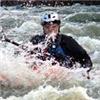
Access points were a bit less than optimum and required scrambling up the rip-rap at the take out to avoid the mud. The first couple of miles were pretty heavily impacted by bank erosion, with many logs and trees in the river, but none that required portaging. After that, there were some really pretty bluffs. We heard quite a few birds, and DeBo saw a barred owl. We also briefly chased a deer as it swam downriver, but never got really close.
From a WW perspective, it was both easier than Cadron, and potentially harder if you didn't have basic eddy-catching skills to help stay away from the many overhanging trees and logs. Nothing required bank scouting; it was always pretty obvious what you needed to do. At higher levels there might be some decent surfing at two or three places, but at this level it was just floating over easy shoals. (Today's level on Cadron was 2.95', at this level I would call Cove "low but floatable".)
I think I'd like to go back at a slightly higher level to see if any of those shoals develop some really good surfing waves.

More here: http://outdoors.webshots.com/album/582173355XTAYrU" onclick="window.open(this.href);return false;
Access points were a bit less than optimum and required scrambling up the rip-rap at the take out to avoid the mud. The first couple of miles were pretty heavily impacted by bank erosion, with many logs and trees in the river, but none that required portaging. After that, there were some really pretty bluffs. We heard quite a few birds, and DeBo saw a barred owl. We also briefly chased a deer as it swam downriver, but never got really close.
From a WW perspective, it was both easier than Cadron, and potentially harder if you didn't have basic eddy-catching skills to help stay away from the many overhanging trees and logs. Nothing required bank scouting; it was always pretty obvious what you needed to do. At higher levels there might be some decent surfing at two or three places, but at this level it was just floating over easy shoals. (Today's level on Cadron was 2.95', at this level I would call Cove "low but floatable".)
I think I'd like to go back at a slightly higher level to see if any of those shoals develop some really good surfing waves.
More here: http://outdoors.webshots.com/album/582173355XTAYrU" onclick="window.open(this.href);return false;
Trash: Get a little every time you go!
Re: Cove Creek Sunday, 1/15/12
Cowper,
Thanks for the report. When I paddled that same strectch the "waterfall" in your picture was only about a 1.5ft. drop so I guess my recollection of the water being at about 5ft. or so was farely accurate. To me it seemed that the first couple of miles had adjacent farmland/pasture and then after you hit the first bluff line on river right it becomes much more scenic. One of the locals calls that rock formation devil's chimney. It's a pretty sweet bluff line through that section and immediately after. I'm glad you guys were able to make and I'm sorry I couldn't this time.
Thanks for the report. When I paddled that same strectch the "waterfall" in your picture was only about a 1.5ft. drop so I guess my recollection of the water being at about 5ft. or so was farely accurate. To me it seemed that the first couple of miles had adjacent farmland/pasture and then after you hit the first bluff line on river right it becomes much more scenic. One of the locals calls that rock formation devil's chimney. It's a pretty sweet bluff line through that section and immediately after. I'm glad you guys were able to make and I'm sorry I couldn't this time.
-
Cowper
- .....
- Posts: 2423
- Joined: Sun Jul 10, 2005 10:39 am
- Name: Cowper C
- Location: Conway, AR
- Contact:
Re: Cove Creek Sunday, 1/15/12
Thanks, I'll update the tag to use the local name.
I was a little surprised that when we went past Camp Kiwanis, there was no obvious spot where they come down and access the river. I was expecting to see a table, steps, obvious beach area, or something.
The canoe half we found doesn't really look like river damage. The seat is gone as if the screws were loosened to remove it, and the cut is clean and straight. Don't know if it was wrapped and someone tried to free it in pieces, or is there some other story there?
Trash: Get a little every time you go!
Re: Cove Creek Sunday, 1/15/12
That looks like a neat creek. You were very proud with that smile finding that half a canoe to pull down river. The waterfall is beautiful. Love to paddle it sometime. Let me know when you go back as I would love to go. Call me or post a trip.
-
gannon311
- .....
- Posts: 708
- Joined: Wed Jul 02, 2008 6:09 pm
- Name: jeff gannon
- Location: Woolverton MTN.
Re: Cove Creek Sunday, 1/15/12
Coop, what are u going to do with the 1/4 canoe? That waterfall is on my to do list. I drive by it everyday going to work. It looks pretty sweat, only problem is the caldron has to be down like in the pic and get a good rain. it's a 10 fter or so but the river starts to rise and it gets smaller. The stars have to line up and every time they do I can't get it!
http://community.webshots.com/user/gannon311" onclick="window.open(this.href);return false;
Social Media
Who is online
Users browsing this forum: No registered users and 1 guest