I have hiked 80% of this creek and added more photos to the link.
http://sports.webshots.com/slideshow/582339133yRUGYx" onclick="window.open(this.href);return false;
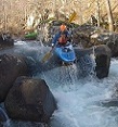
It's starting to look unbelievable, so good that many people are bound to have paddled it. Tell us if you have. I'm going to go for the first "published descent" if no one comes forward.
Even though the gradient is only shown as an average 37 feet per mile, this creek has not stopped it's charge forward yet as far as I have hiked. Maybe it's another case of map error, which I have experienced before.


Creek B needs some brush trimming; Salivation Creek needs permission to be granted by the landowner to put in and the take-out requires a three quarter mile up river paddle followed by a two mile drag on basically level ground. Creek C is ready to go.
Captain Aleve, alias Mike Coogan