Some if not most of you are aware that there is now a completed hiking trail in the Cossatot River Corridor. Well anyway I have been working with Charlie Williams at ouachitamaps.com to get a map completed of this trail. Well he is also working on a whitewater version. It is in Google maps format. It shows all of the rapids. If you would like to check it out go to
http://www.ouachitamaps.com/Cossatot.html
it is on the bottom right and it will expand. Eventually I will be writing the trail description and some of my pictures will be used. We are waiting on the GPS tracks to come from Little Rock.
Cossatot River Corridor Trail map and whitewater version
-
ouachita hiker

- ..

- Posts: 193
- Joined: Mon Jun 01, 2009 8:55 am
- Name: Tom Trigg
- Location: Horshoebend Campground
- Contact:
Cossatot River Corridor Trail map and whitewater version
Not your typical camp ground host!
Big Tom T.
Big Tom T.
-
Adam Willard

- ..
- Posts: 138
- Joined: Tue Apr 06, 2010 9:32 pm
- Name: Adam Willard
Re: Cossatot River Corridor Trail map and whitewater version
WOW Tom, thanks for all your hard work and keeping us in the loop. Hope to see you soon!!
Sincerely,
Adam Willard
Adam Willard
-
ouachita hiker
- ..
- Posts: 193
- Joined: Mon Jun 01, 2009 8:55 am
- Name: Tom Trigg
- Location: Horshoebend Campground
- Contact:
Re: Cossatot River Corridor Trail map and whitewater version
Save that link and when he has the gps tracks and the map is finished I will keep every one informed.
Not your typical camp ground host!
Big Tom T.
Big Tom T.
-
ouachita hiker
- ..
- Posts: 193
- Joined: Mon Jun 01, 2009 8:55 am
- Name: Tom Trigg
- Location: Horshoebend Campground
- Contact:
Re: Cossatot River Corridor Trail map and whitewater version
I would like to say if there is anything, in a map, that the floating comunity would like to see added please let me know. Charlie Williams is very open to this type stuff. Also note the maps will be free to copy when he gets them done or you can order from him on water proof paper for just $5!Adam Willard wrote:WOW Tom, thanks for all your hard work and keeping us in the loop. Hope to see you soon!!
Not your typical camp ground host!
Big Tom T.
Big Tom T.
-
Cowper

- .....

- Posts: 2423
- Joined: Sun Jul 10, 2005 10:39 am
- Name: Cowper C
- Location: Conway, AR
- Contact:
Re: Cossatot River Corridor Trail map and whitewater version
My nominations for "floater information" would be:ouachita hiker wrote:I would like to say if there is anything, in a map, that the floating comunity would like to see added please let me know. Charlie Williams is very open to this type stuff.
1) GPS coordinates for the major access points and developed camps
2) The River gage phone number.
3) Recommended "minimum, good, and "high" gage levels (probably 3' (bare minimum), 4' (pretty nice), 5' (getting pretty pushy by most folks standards; those who can safely float it higher already know who they are, but for maps you want to use a "conservative" number to keep folks out of trouble)
One other very minor suggestion - I wouldn't call it the "best whitewater run in the state". We love it, but we love others too. If space permits I would suggest you replace this:
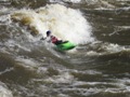
For kayakers, the river is considered the best white water in the state.
With this:
For kayakers and expert-level canoeists, the river is considered one of the best white water runs in the state.
Trash: Get a little every time you go!
-
ouachita hiker
- ..
- Posts: 193
- Joined: Mon Jun 01, 2009 8:55 am
- Name: Tom Trigg
- Location: Horshoebend Campground
- Contact:
Re: Cossatot River Corridor Trail map and whitewater version
I will forward this info to Charlie.
Thanks!
Thanks!
Not your typical camp ground host!
Big Tom T.
Big Tom T.
-
ouachita hiker
- ..
- Posts: 193
- Joined: Mon Jun 01, 2009 8:55 am
- Name: Tom Trigg
- Location: Horshoebend Campground
- Contact:
Re: Cossatot River Corridor Trail map and whitewater version
I forwarded the above info to Charlie and this is his reply this morning:Cowper wrote:My nominations for "floater information" would be:ouachita hiker wrote:I would like to say if there is anything, in a map, that the floating comunity would like to see added please let me know. Charlie Williams is very open to this type stuff.
1) GPS coordinates for the major access points and developed camps
2) The River gage phone number.
3) Recommended "minimum, good, and "high" gage levels (probably 3' (bare minimum), 4' (pretty nice), 5' (getting pretty pushy by most folks standards; those who can safely float it higher already know who they are, but for maps you want to use a "conservative" number to keep folks out of trouble)
One other very minor suggestion - I wouldn't call it the "best whitewater run in the state". We love it, but we love others too. If space permits I would suggest you replace this:
For kayakers, the river is considered the best white water in the state.
With this:
For kayakers and expert-level canoeists, the river is considered one of the best white water runs in the state.
Great feed back. I'll make the changes this weekend.
Right now I just know of the two highways, Ed Banks and Sandbar. Any other access? Also I can give the waypoints for those crossings, but if I knew where the puts in were, I might be able to do better. E.g. NW of Ed Banks xing. I might be able to see the high traffic area.
Now if some one could answer his questions he will make the changes. Either answer here or PM me.
Not your typical camp ground host!
Big Tom T.
Big Tom T.
Re: Cossatot River Corridor Trail map and whitewater version
There is also the Highway 246 put in/takeout (Brushy Creek Recreation area) near Vandervoort. There is also the takeout near the Cossatot Visitor Center at Highway 278.
-
ouachita hiker
- ..
- Posts: 193
- Joined: Mon Jun 01, 2009 8:55 am
- Name: Tom Trigg
- Location: Horshoebend Campground
- Contact:
Re: Cossatot River Corridor Trail map and whitewater version
Thanks Renee.Renee H wrote:There is also the Highway 246 put in/takeout (Brushy Creek Recreation area) near Vandervoort. There is also the takeout near the Cossatot Visitor Center at Highway 278.
We already had those down. I think the specific info that Charlie is looking for is specifics, if there are any, that isn't in print any were else.
Not your typical camp ground host!
Big Tom T.
Big Tom T.
-
Lazer

- ..
- Posts: 158
- Joined: Mon Jul 04, 2005 10:51 am
- Location: Home, Office, River (but not always in that order)
Re: Cossatot River Corridor Trail map and whitewater version
A list of many of the State's river segments with access data points are located on American Whitewater
http://www.americanwhitewater.org/conte ... /state/AR/
Specifically for the area you are looking at
Brushy Creek
Upper Cossatot - 31 to 246
Cossatot - 246 to Ed Banks
Cossatot - Ed Banks to 278
Lower Cossatot - Below Gillham Dam
Camp/Flat Creek
Baker Creek
Harris Creek
Moore Creek
http://www.americanwhitewater.org/conte ... /state/AR/
Specifically for the area you are looking at
Brushy Creek
Upper Cossatot - 31 to 246
Cossatot - 246 to Ed Banks
Cossatot - Ed Banks to 278
Lower Cossatot - Below Gillham Dam
Camp/Flat Creek
Baker Creek
Harris Creek
Moore Creek
Social Media
Who is online
Users browsing this forum: No registered users and 5 guests