FLOOD EXPOSES OLD TIMBER DAM AT ROCKPORT LOWER LEDGE

Open Discussion
Post Reply
       
CAPTAIN ALEVE
.....
.....
Posts: 730
Joined: Fri Jul 01, 2005 2:19 pm
Name: Mike Coogan
Location: Little Rock
Contact:

FLOOD EXPOSES OLD TIMBER DAM AT ROCKPORT LOWER LEDGE

Post by CAPTAIN ALEVE » Sat Jan 23, 2010 5:43 pm

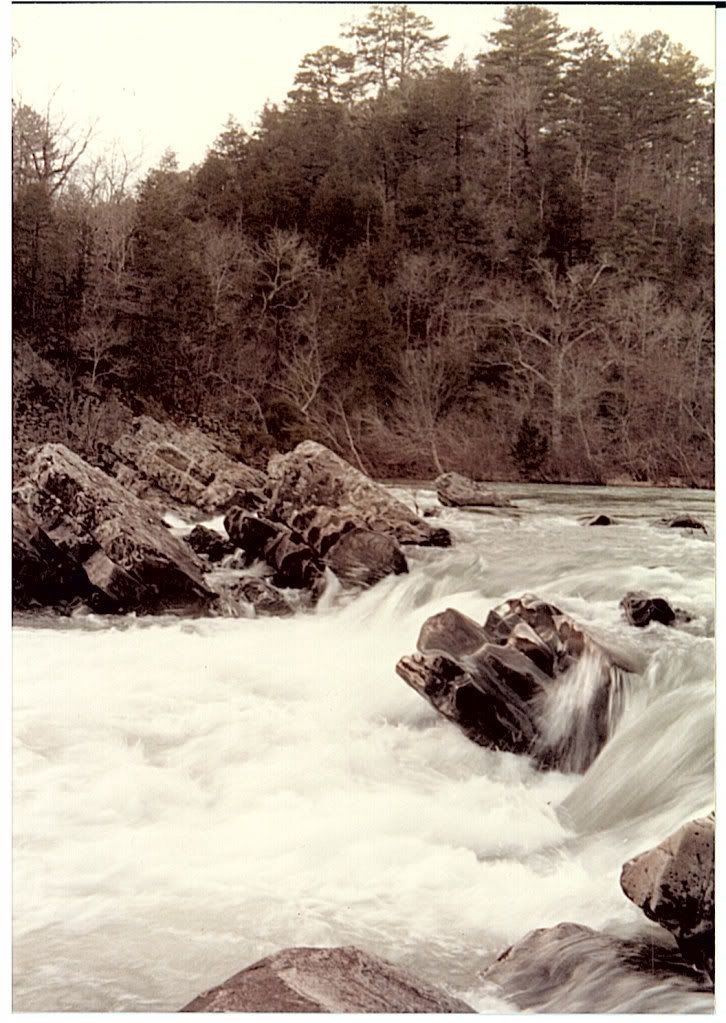
The last big flood on the Ouachita River at Malvern a few weeks ago hit about 80,000 cfs and further scoured the entrance to the swiftwater rescue training channel. These photos show a newly uncovered section of the cribbing dam built in the late 1800s, as described in the 404 Permit research done by the Highway Department for the new Tanner Street Bridge project. It looks like the channel has been getting deeper and washing away logs from the formerly buried dam ever since the bridge contractor accidentally dug up part of the cribbing.

LOOKING DOWNSTREAM, ALONG WEST BANK

Image


LOOKING UPSTREAM, ALONG WEST BANK

Image


LOGS STUB OUT FROM THE BANK, MORE LOGS RUN PARALLEL TO THE FLOW OR WERE WASHED INTO THAT POSITION

Image


THERE IS A SECOND LOG JUST UNDER THE WATER SURFACE, ABOUT 4 FEET CLOSER TO THE BANK; THAT SUGGESTS THE LOGS WERE LAID PARALLEL TO THE FLOW

Image

Mike Coogan, alias Captain Aleve
Last edited by CAPTAIN ALEVE on Sat Jan 23, 2010 7:03 pm, edited 5 times in total.
PHOTOS: http://www.flickr.com/photos/17863908@N03/sets/" onclick="window.open(this.href);return false;

More paddling info at http://class2arkansas.com/" onclick="window.open(this.href);return false;

CAPTAIN ALEVE
.....
.....
Posts: 730
Joined: Fri Jul 01, 2005 2:19 pm
Name: Mike Coogan
Location: Little Rock
Contact:

Re: FLOOD EXPOSES OLD TIMBER DAM AT ROCKPORT LOWER LEDGE

Post by CAPTAIN ALEVE » Sat Jan 23, 2010 5:49 pm

Somebady tell me how to make the images show up. I clicked on the Img box and pasted the online address of the photos between the [img] boxes, but I'm not seeing the pics.

Captain "Computer Illiterate" Aleve
PHOTOS: http://www.flickr.com/photos/17863908@N03/sets/" onclick="window.open(this.href);return false;

More paddling info at http://class2arkansas.com/" onclick="window.open(this.href);return false;

User avatar
Roger
.....
.....
Posts: 1473
Joined: Fri Jul 01, 2005 12:32 pm
Location: Right behind you!

Re: FLOOD EXPOSES OLD TIMBER DAM AT ROCKPORT LOWER LEDGE

Post by Roger » Sat Jan 23, 2010 6:15 pm

Mike, not sure what photo-share site you are using to link the photos, but check and see what available links can be had. They look like this:

Email & IM
Direct Link
HTML Code
IMG Code

I think the one you need is: IMG Code. This what happens when I use that one on Photobucket.

[imgImage][/img]

Then hit preview. Iffen you don't see that in preview, it's not there.
I am I plus my surroundings and if I do not preserve the latter, I do not preserve myself. Jose Ortega Y Gasset

The earth is like a spaceship that didn't come with an operating manual.
Buckminster Fuller

CAPTAIN ALEVE
.....
.....
Posts: 730
Joined: Fri Jul 01, 2005 2:19 pm
Name: Mike Coogan
Location: Little Rock
Contact:

Re: FLOOD EXPOSES OLD TIMBER DAM AT ROCKPORT LOWER LEDGE

Post by CAPTAIN ALEVE » Sat Jan 23, 2010 7:06 pm

Thanks, Roger. I found the link info on the photo webpage after you told me where to look.

Cap'n
PHOTOS: http://www.flickr.com/photos/17863908@N03/sets/" onclick="window.open(this.href);return false;

More paddling info at http://class2arkansas.com/" onclick="window.open(this.href);return false;

CAPTAIN ALEVE
.....
.....
Posts: 730
Joined: Fri Jul 01, 2005 2:19 pm
Name: Mike Coogan
Location: Little Rock
Contact:

Re: FLOOD EXPOSES OLD TIMBER DAM AT ROCKPORT LOWER LEDGE

Post by CAPTAIN ALEVE » Mon Jan 25, 2010 8:51 pm

Minimum flow revealed more of the timbers:

Image


ROW OF SMALLER TIMBERS IN FOREGROUND

Image


150 YEAR OLD SPIKE ?

Image


MAIN LOGS ARE BIG

Image


LEVIATHAN LEVITATING

Image

Captain Aleve, alias Mike Coogan
PHOTOS: http://www.flickr.com/photos/17863908@N03/sets/" onclick="window.open(this.href);return false;

More paddling info at http://class2arkansas.com/" onclick="window.open(this.href);return false;

User avatar
Jim Krueger
.....
.....
Posts: 1867
Joined: Thu Jun 30, 2005 1:54 pm
Location: Benton, AR

Re: FLOOD EXPOSES OLD TIMBER DAM AT ROCKPORT LOWER LEDGE

Post by Jim Krueger » Mon Jan 25, 2010 10:43 pm

Mike,

I have a centennial publication published by the Malvern Daily Record that my Grandmother, who lived there ,saved from 1960 or so. It's getting more fragile by the year now but still good enough to look at and make some photo copies. At any rate, some of the shots of note include; all that cribbing/dams you're referring to when they were new and in use by the timber companies that built them, as well as a picture of the old iron Rockport bridge on the day it was dedicated and opened for use. Also a shot of The Ledge from the same period.

Best Regards
Jim

CAPTAIN ALEVE
.....
.....
Posts: 730
Joined: Fri Jul 01, 2005 2:19 pm
Name: Mike Coogan
Location: Little Rock
Contact:

Re: FLOOD EXPOSES OLD TIMBER DAM AT ROCKPORT LOWER LEDGE

Post by CAPTAIN ALEVE » Wed Jan 27, 2010 10:18 am

Here's a photo from Jim's source that shows the lumber company on the east side of the river, the large rock outcrop coming from the east bank that the new Tanner Street bridge passes over. Notice the foot bridge between the rock outcrop and the main rock formation extending from the bank. There is a bridge support in that low area now. Jim says the structures in the photo were used to catch logs that were floated downstream in times of flood.

Image


Awesome! Timber cribbing filled with rocks! The logs now visible near the west bank appear to be of the same type of construction.

Captain Aleve, alias Mike Coogan
PHOTOS: http://www.flickr.com/photos/17863908@N03/sets/" onclick="window.open(this.href);return false;

More paddling info at http://class2arkansas.com/" onclick="window.open(this.href);return false;

User avatar
Jim Krueger
.....
.....
Posts: 1867
Joined: Thu Jun 30, 2005 1:54 pm
Location: Benton, AR

Re: FLOOD EXPOSES OLD TIMBER DAM AT ROCKPORT LOWER LEDGE

Post by Jim Krueger » Wed Jan 27, 2010 10:44 am

Thanks for posting this for me Mike! There are many more interesting photos in the publication and much good text. In this particular shot you can also see the company owned bridge spanning the river. Evidently it was used on a toll basis for the public during the same time the ferry on Military Rd. was also in use.
The list of toll charges was entertaining. The article was dated July 5th, 1887. Although the article indicated July, the picture indicated maybe mid-winter due to the lack of foliage...

Another interesting shot in the publication appears to have been made looking downriver from Rockport in 1918 ,when the river was frozen from bank to bank.


Best Regards
Jim

Post Reply

Social Media


Who is online

Users browsing this forum: Google [Bot] and 2 guests