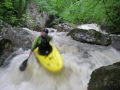
First Descent of Upper Chickalah Creek
Re: First Descent of Upper Chickalah Creek
That is not the first run off of that mountain. There are other forks that have some great drops. One notably called chickalah falls. Did u guys see that sweet cabin right on the creek?
-
FarPastGone
- ....

- Posts: 499
- Joined: Thu Dec 13, 2007 12:25 pm
- Name: Matt
- Location: Not Sure
- Contact:
Re: First Descent of Upper Chickalah Creek
Hey Joe, did ya'll run that stretch of Chickalah already or are you saying that ya'll have run other creeks off of Mt. Magazine? I asked around and did not hear of anyone who had done it. We hiked out of the gorge after the slides and drops, but I think I know what cabin you are refering to, it is towards the bridge on Spring Lake Rd/1600/CR-35.
For sure, give credit where credit is due if ya'll have already given 'er.
- Matt
For sure, give credit where credit is due if ya'll have already given 'er.
- Matt
Re: First Descent of Upper Chickalah Creek
I'm not sure if Joe has a username.
And no, we didn't run that one. We ran a tributary. What I meant was there is more to be had up there.
Good job on getting some film though, it's so hard in those small gorges.
Josh
And no, we didn't run that one. We ran a tributary. What I meant was there is more to be had up there.
Good job on getting some film though, it's so hard in those small gorges.
Josh
Re: First Descent of Upper Chickalah Creek
How about a GPS fix on the put in and take out. I like to hike creeks that are above my skill level .
-
FarPastGone
- ....
- Posts: 499
- Joined: Thu Dec 13, 2007 12:25 pm
- Name: Matt
- Location: Not Sure
- Contact:
Re: First Descent of Upper Chickalah Creek
Thanks Josh, I'd be curious to hear about those tribs of Chickalah and run some other creeks I have in mind by you.
Bird dog, I am not sure about GPS points, but to get to the put-in you take CR-35/Spring Lake Rd from New Blaine, turn right on CR-25 (or Spring Lake Rd). From there you will pass a turn on your right that goes into a camping area then you will come to a road on your right that a small creek crosses. That is the put-in. Take-out is about 1/4-1/2 mile from that campground on an ATV trail then down! Sorry if that is not much help.
- Matt
-
anthony
- ...

- Posts: 312
- Joined: Thu Jun 07, 2007 2:40 pm
- Name: Anthony Moats
- Location: RUSSELLVILLE
- Contact:
Re: First Descent of Upper Chickalah Creek
yell county whitewater!!!
Re: First Descent of Upper Chickalah Creek
Yes, I am gonna try to locate it from Hwy 27 (Harkeys Valley Road)anthony wrote:yell county whitewater!!!

Re: First Descent of Upper Chickalah Creek
I think the put-in is about 35°11'18.42"N 93°28'38.00"W. Just guestimating from Google maps.
-
anthony
- ...
- Posts: 312
- Joined: Thu Jun 07, 2007 2:40 pm
- Name: Anthony Moats
- Location: RUSSELLVILLE
- Contact:
Re: First Descent of Upper Chickalah Creek
bird dog, hey its off spring lake road, ie going toward spring lake going off the north side of chicklah mtn. harkeys valley road is way north of it
Re: First Descent of Upper Chickalah Creek
Found it on Goolge earth and topo maps also, the road intersection is at the "gum tree". as know to locals.
Re: First Descent of Upper Chickalah Creek
Thanks for the GPS Fix!bird dog wrote:Found it on Goolge earth and topo maps also, the road intersection is at the "gum tree". as know to locals.
-
CAPTAIN ALEVE
- .....

- Posts: 730
- Joined: Fri Jul 01, 2005 2:19 pm
- Name: Mike Coogan
- Location: Little Rock
- Contact:
Re: First Descent of Upper Chickalah Creek
When I try to view videos on Vimeo they don't run smoothly, they kind of have a strobe effect. What can I do to smooth them out?
Captain Aleve, alias Mike Coogan
Captain Aleve, alias Mike Coogan
PHOTOS: http://www.flickr.com/photos/17863908@N03/sets/" onclick="window.open(this.href);return false;
More paddling info at http://class2arkansas.com/" onclick="window.open(this.href);return false;
More paddling info at http://class2arkansas.com/" onclick="window.open(this.href);return false;
Re: First Descent of Upper Chickalah Creek
So when do we clear out the rest of the creek? I can use a chainsaw and run a trot line, cause a country boy can survive...
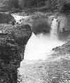
Or we just could install a ski lift on that boulder pile cliff where we took out. But climbing that thing certainly makes you think twice about doing laps on a creek that is just begging for multiple laps.
- Fish
Or we just could install a ski lift on that boulder pile cliff where we took out. But climbing that thing certainly makes you think twice about doing laps on a creek that is just begging for multiple laps.
- Fish
-
JackZ

- .

- Posts: 55
- Joined: Sat Jul 02, 2005 6:48 pm
- Name: Jack Zwaan
- Location: North Little Rock, AR
- Contact:
Re: First Descent of Upper Chickalah Creek
Looks like it's going to get hit pretty hard. I wouldn't be able to go but I would love to see more video of this creek. 
Social Media
Who is online
Users browsing this forum: Google [Bot] and 1 guest