Terry, just drive another 15 minutes over to Forsyth and Casey Rd. at Swan Creek. The 1 mile of play parrallels the road. This falls within the inundation corridor of Bull Shoals Lake. If Bull Shoals is 30+ feet over power pool (elevation 654 ft.) Then this starts pooling up. Same problem as Bear Creek AR. I ususally make it down there a couple times after work every spring. Caught it last fall on a Saturday am when I had evening commitments and no one was there. Branson can't develop this park and play.
Brent
Long creek in taney county mo
-
elduderino
- .

- Posts: 36
- Joined: Mon Mar 24, 2008 1:32 am
- Location: Springfield, MO
- Contact:
Re: Long creek in taney county mo
I just checked my paddling notes from the Turkey creek run, and we put in on Sandy Lane, try google mapping this for exact directions. This is exactly what I wrote down:
The put-in was south on 65, turning left (east) onto Road 65-190, then right turns onto Fruit Farm road, then Blue ridge dr, then Sandy Lane, which is a tough downhill drive to the put in.
As I remember it, if the creek is running, you cannot miss it from the bottom of the hill road. It's a tough drive down there, but you basically put in right off the road into the creek. Be careful, there are two different places where a barb wire fence runs across the creek, also there were the common strainer problems and two major sweepers I recall.
The Bull creek is the place I frequent most often, and I have to say, the park n play at the low water bridge is better than Shady Rapids. The eddy service is great, and you don't have to work as hard to get back to where you need to be. The parking issues at Shady Rapids become more and more complex, last time I was there (March), they were building homes in the clearing. I have been told that if you park on shady rapids road BEFORE you get to the sign which says county maintenance ends here (or something like that), you are on public road, not private property. I think the paddle from Goodnight hollow just isn't worth it.

Re: Long creek in taney county mo
All the talk about access issues for bull creek has gotten me thinking....
I float the upper-upper stretch pretty often because a friend has land there and likes to float. He has a good takeout on a somewhat hairy road, and we often put in on center road and take out at his place. There is good playing and some good drops on this section, and it is short. He might be open to taking a couple of bucks or some free beer to let people use his takeout. The red bridge road takeout is steep, muddy and there is only space for one small car to park. I will talk to him and see what he says. I don't want to say anything yet because I don't want to misrepresent his wishes.
I also find myself going ninja or low profile in order to get to creeks I want to do. Before I knew anyone at saddlebrooke, I ran the little creek in there at flood. A guy asked me what I was doing and said I knew someone who was thinking of buying land there. It wasn't the whole truth, and he was skeptical, but I acted like I was in a hurry and moved on quickly before he changed his mind.
I dug up some pictures of the waves at casey road on swan creek. It is at a low level and they get a lot bigger. Also there is one monster wave/hole on this stretch that developes at some higher levels, and i don't have a picture of that. Wish I did.
- Attachments
-
-
-
fryingsquirrel

- ....

- Posts: 395
- Joined: Mon Feb 09, 2009 2:42 pm
- Name: Jon Ellwood
- Location: Little Rock, Ar
Re: Long creek in taney county mo
I grew up in Springfield, and have been to Hercule's Glade many times. I even spent a memorable night camped out in the firetower. Been on the hike to Long Creek a few times, and the falls can be beautiful in the spring after a good rain. I'm no creeker (yet) so it never occurred to me to take a boat down it. Since we are discussing MO creeks and falls I was wongering if anyone has ever tried to run Rocky Falls, near Eminence? That was another place I grew up going to to swim, take pictures, and goof off at. Now that I'm a slightly decent paddler, it occurs to me that that may be fun to run with enough water. So has anyone ever tried it?

Here's a good shot of it, I know Terry knows of it, but I'm not sure who else up there knows.
Another shot, this one with higher water:

Looks like there may be some paint lost without good high water, but time (or a descent report) will tell.
My .02
Jon Ellwood
Conway, Ar
Here's a good shot of it, I know Terry knows of it, but I'm not sure who else up there knows.
Another shot, this one with higher water:
Looks like there may be some paint lost without good high water, but time (or a descent report) will tell.
My .02
Jon Ellwood
Conway, Ar
"Life is a question asked by nature and answered by death. You are a different kind of question with a different kind of answer." -Helios

Re: Long creek in taney county mo
Thanks, Brent.
I'll give it a look-see on my next Out-and-About! Dan's photos look pretty good. I have run Swan back in the Back Then! Just never went there to park & play mostly because I always liked Bull or went on down to Bear. Swan seems to be pretty popular with a lot of the OC boaters in our area. Brian S., Dr. John T., to name a couple. Was big with Gene and Tom of Rivermadness! Some Parties of Legend from back then! I can certainly see why. Same reason Bull was for me. Right in the ole Back Yard! You can head down there, get your fill, and be back for dinner! Plus it is in line with Bull and Roark. You can actually do all three in a day if you get a good jump on it at the right time of year.
Personally, I am not a big fan of "stealth" accesses. Not really too sure it breeds much goodwill between landowners and boaters. That is why we always called for parking permission at Shady. The landowners never refused us and were happy that we called. Naturally, after the session, we always policed the area for trash, re-called the owner to thank them, and mentioned we de-trashed the place. Also mentioned any problems or new developments on their property. The owners really seemed to dig this kind of interaction with their property. For the last many years, the owners were off-site owners and didn't really make it down there too much. Though for a while there were caretakers who lived in the trailer up the hill. I always saw tons of people who didn't do this there and I figured one day that would bite us all in the butt.
Who knows? Maybe with the right approach, permission could be granted by the new ownership at Shady when they get done doing whatever they're doing! I won't hold my breath, however!
Keep Your Stick in the Water!
-Terry-
-Terry-
-
perspective7
- ....
- Posts: 487
- Joined: Tue Feb 10, 2009 6:20 pm
- Name: Seth
- Location: Springfield, MO 417-761-9091
- Contact:
Re: Long creek in taney county mo
We were down at Shady Rapids earlier this year with some of the first rains. We put-in at round mountain and paddled down to Walnut Shade. There were quite a few boaters that came down and did the "park and play" thing...probably 12 of us all together. About 4 of us started from above I think. I ran into a guy doing work for the guy that bought the property on a solo surfing trip down there and got the owners name, but I don't remember what it was. He owns a construction company is all I remember. We need to get a hold of this guy and see if he is cool with boaters coming down there since most of us aren't rowdy and don't trash the river...paddle across the water leaves no trace...
I don't think I have the ba**s to do Rocky Falls...haha...That's a long banged up ride down unless you happen to stay upright...which I don't see happening Jon! I'd love to watch someone else do it!
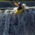
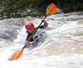
Here are a few pics from earlier this year...
Bull Creek 3,400 CFS 8ft


Round Mountain "death slab"


Surfin' the Bar-K falls on Swan creek in the ol' wavesport frankenstein

I don't think I have the ba**s to do Rocky Falls...haha...That's a long banged up ride down unless you happen to stay upright...which I don't see happening Jon! I'd love to watch someone else do it!
Here are a few pics from earlier this year...
Bull Creek 3,400 CFS 8ft
Round Mountain "death slab"
Surfin' the Bar-K falls on Swan creek in the ol' wavesport frankenstein
Re: Long creek in taney county mo
You know Terry, I will take my chastizement, you are right that going ninja doesn't breed goodwill with landowners. Sometimes I think that we are seen as no different than the rednecks that sit on their coolers and shoot fireworks into the creek while jamming to whitesnake with the volume cranked to 11. I have people yell out to me that I was crazy for being on a brownwater creek. I almost thought I was going to have to fight a guy who called me a looter when I took out at bull creek village. I was wearing a helmet, skirt and walking through a field with my boat since the normal access was under water. I don't know what looters dress like, but they probably don't wear kayak gear and walk through crowds of onlookers in broad daylight.
Since I don't for the most part park and play, I guess I am not as sensitive to the crowding at shady rapids. If I got there and saw that many yakkers, I would drive on to the next creek. Since I am close, and usually run my own shuttle on my bike, I usually get on the water early after a brownwater event. I almost never see anyone else at bull. If you go on the sunny, high pressure day with blue water, the day after the brown, it looks like it can get more crowded.
Me and my friends have always called shady rapids the colliseum, since it kind of looks like there are columns of roman architecture from a distance. You are straining to see which lines are open this time since it changes everytime.
The round mountain slab is dangerous sure, but It has two lines available where the hydraulic is weak. We have been running it for years, but I did see a beatdown there that resulted in a lost boat, and i don't think I have ran that since.
I am no geologist, but is that granite or rhyolite rock causing the falls at rocky falls. It definately looks Igneous. If so I thought all of that type of rock was more east.
I just got the call so I am going to try to put some roof decking on a new house in the rain this morning, I must be stupid, crazy or poor. Maybe all three.
Later
Dan
-
RussellPresley
- .
- Posts: 54
- Joined: Thu Feb 04, 2010 8:16 pm
- Name: Russell Presley
Re: Long creek in taney county mo
It's been years since i ran Bear Creek up at LeadHill what does the gauge have to read for a decent run I forgot.
-
fryingsquirrel
- ....
- Posts: 395
- Joined: Mon Feb 09, 2009 2:42 pm
- Name: Jon Ellwood
- Location: Little Rock, Ar
Re: Long creek in taney county mo
Dan, you are correct, the rock at Rocky Falls is an old lava flow, from not too distant geologic history. The whole eastern/southeastern section of MO is still geologically active. If you have ever been to Johnson's Shut-Ins, you'll see lots more igneous rocks. Ever hear about the New Madrid fault line? There are several small tremors there a year (about one between 1.5 and 2.0 every other day), and several BIG ones were recorded in 1811-1812: http://en.wikipedia.org/wiki/1812_New_Madrid_earthquake
It is a section of MO I've always been interested in, and was just about required learning in school. I've got some real good shots of the falls and shut-ins from when I was a teenager learning photography, but I think most of those pics are lost to the Annals of Obscurity...
Check out the area if you get the chance, Elephant Rocks state park is another interesting geologic site, where a granite dome became exposed to the elements, and after eons of weathering and erosion, chunks fractured from it, and were separated and rounded by even more erosion. Here's a very characteristic photo of the boulders:

That about covers it, and I think I just showed off my true Missouri colors... Sorry guys.
Jon Ellwood
It is a section of MO I've always been interested in, and was just about required learning in school. I've got some real good shots of the falls and shut-ins from when I was a teenager learning photography, but I think most of those pics are lost to the Annals of Obscurity...
Check out the area if you get the chance, Elephant Rocks state park is another interesting geologic site, where a granite dome became exposed to the elements, and after eons of weathering and erosion, chunks fractured from it, and were separated and rounded by even more erosion. Here's a very characteristic photo of the boulders:
That about covers it, and I think I just showed off my true Missouri colors... Sorry guys.
Jon Ellwood
"Life is a question asked by nature and answered by death. You are a different kind of question with a different kind of answer." -Helios
Re: Long creek in taney county mo
Jon you brought to light a subject that has fascinated me since childhood, geology! And more importantly how bedrock geology forms the rapids we love. I loved geology in college, and still read books on the subject.
I would loosely classify rapids into the following types. I make the distinction between rapids formed by boulders and ones formed by bedrock, since when boulders become detached from bedrock they are subject to being moved around by water or gravity.
Limestone/Dolestone
This is the most water soluble type of rock so when it is exposed to stream erosion the stream tends to cut a sluice in high gradient situations, and in lower gradient situations it can peel off in sheets. This type of rock is most common in my area. It is great for forming waves and ledge drops.
Shale
This is by far the softest of the bedrocks. It is formed by ancient silt deposits, and due to its low solubility, it doesn't crystalize and bond to itself. It is not often exposed to the surface except in higher gradient streams. It is so crumbly that it almost always forms grottos and waterfalls in conjunction with the layer of harder rocks above and below. Most of the waterfalls in the boston mountains are shale based. Heat shale enough and you get slate.
Sandstone
This is the most common rapid maker in arkansas. It is much less common in the missouri ozarks, but it is here. It combines extremely low solubility with high strength and hardness. It readilly forms boulders and that is why we love it. Look at the sandstone wall in the beech creek photo. See how it tends to break off in chunks, while the limestone that is forming the bedrock under the wall is smoother and is eroding in sheets. Sandstone is the primary boulder maker.
Igneous rocks
They are old lava flows such as rhyolite or basalt. Or old bedrock such as granite. They are extremely hard and resistant to weathering. They form the shut ins that are famous in eastern missouri. Look at Jons photo of rocky falls.
Not all stream rapids are easilly categorized. Some are formed by a combination of factors, so of course the above summary is a simplification.
- Attachments
-
- Beech creek sandstone wall
-
- The shale is so soft it sinks back alowing the harder sandstone to overhang
-
- Limestone bedrock rapid on Beech creek
Re: Long creek in taney county mo
Dan, no chastisement intended!
I would be lying if I said I have never done it myself!
But I do believe in furthering land owner/boater relations every chance we get. It can make the difference in having access or not and can go a long ways in relieving the way we are sometimes perceived by “civilians”! And speaking of perception? I have to agree with your assessment of said.
My 8-track tape of Lynyrd Skynyrd got eaten by blasting it all night long at mega-decibels out of my rusty Trans Am with the doors open! Kind of a difficult situation when I have to go ask my neighbor campers that I have kept up all night for a jump after I have drained my battery!
Gotta get that taken care of before I hit the next campground.
Keep Your Stick in the Water!
-Terry-
-Terry-
-
Sparky
- .
- Posts: 92
- Joined: Wed Apr 15, 2009 1:51 pm
- Name: Brent Glover
- Location: Springfield, MO/Marble Falls, AR
Re: Long creek in taney county mo
To answer Russell's question. The hiway 14 bridge level would start at 1/2 foot up to 2 feet for good surfing. Add 2.2 feet to the USGS internet gauge or 2' bridge=4.2' internet. As Bull Shoals lake rises above power pool (654') it will start backing up Bear Creek. At about 570' I won't bother with Bear because of the lake (reservoir). Due to all the rain and high Bull Shoals I haven't run it in the past 2 years, so I don't know if the gauge is still painted on the bridge. I'm not sure this creek has the following it used to have. Our OMP group used to hit it often. Wide range of surfing opportunities available at optimum level, but Bull Shoals can back up all the way to the put in Bridge at hiway 14. Bull Shoals is at 657' right now, so Bear is good to go from that aspect and here comes the rain.
Dan, have you run Beech Creek AR?
Brent
Dan, have you run Beech Creek AR?
Brent
-
perspective7
- ....
- Posts: 487
- Joined: Tue Feb 10, 2009 6:20 pm
- Name: Seth
- Location: Springfield, MO 417-761-9091
- Contact:
Re: Long creek in taney county mo
Well, we ended up at Roark today and had an excellent couple hours of boating. None of us had ever done Roark because we had never heard much about it. It's a gem of a creek! There are 4-5 drops that around 4 ft with some nasty holes at the bottom, and a couple of class III spots for sure and lots of waves for surfing. Would be wicked in higher water! Not many pools to speak of either...I hate flat water!  Like this one better than Bull creek. No gauge though, which sucks.
Re: Long creek in taney county mo
Did you take in a Shoji Show perspective7?
Roark will wash at high levels. It is good when it is runnable. It is better with a little more than that. After that it is better to watch it and catch it on the way back down.
Besides the Shoji option, the next best thing about Roark is the take out is a hospital!
Convenient if you missed your loop because you were looking at the billboards that line the creek!
I always thought it was kind of different boating a creek that ran through a town!
Very cool that you made it there, perspective7!
Keep Your Stick in the Water!
-Terry-
-Terry-
Re: Long creek in taney county mo
Long creek was fun, I ran it with John and Cricket it could have used a bit more water than when we ran it. Basically you just have to look for locally heavy rain. There is another put in but you have to do some bushwacking. It's only about a 1/4 mile hike down to the creek and it puts you in quite a bit above the trail from the tower. We took out by going down Beaver until Cane flowed in and then paddled up Cane creek to our car. Here's a link to the video I made, also has some pics from Fall Creek in Branson. I do know a guy who knows a guy who talked to a guy who says he's run it before so it probably wasn't a first descent but it was a personal first descent.
http://www.youtube.com/watch?v=UPCWG-g975w
The new owner at Shady Rapids is Tom Boyce. I'm not sure on how he would be with allowing alot of people access. I've never talked to him but my parents have and he gave them permission to go down as long as they weren't there and no parking on the grass. My parents live right up the hill from the creek.
I have looked at Rocky Falls just recently and the first chance I get I'm going to run it. Only problem is you have to cross a couple low water crossings on the road in so you might have to know a good storm was coming and stay the night out there. There are also two other shut in sections further down Rocky Creek that look good to.
A little pain never hurt anyone.
Social Media
Who is online
Users browsing this forum: No registered users and 8 guests