Has anyone ever done this section? And is it worth doing? I can't seem to find any info on this 9.5 mile stretch.
We love the run to the Scottsville bridge from the Hector bridge (7.5 miles), which is class 1-2.
Illinois Bayou, from Scottsville bridge to Hwy 7
-
Sunray and Eve
- .

- Posts: 37
- Joined: Mon Jul 27, 2009 9:05 am
- Name: Stephen Babb
- Location: Dardanelle, Arkansas

Re: Illinois Bayou, from Scottsville bridge to Hwy 7
Very Flat, some good fishing I think. Dale
-
Sunray and Eve
- .
- Posts: 37
- Joined: Mon Jul 27, 2009 9:05 am
- Name: Stephen Babb
- Location: Dardanelle, Arkansas
Re: Illinois Bayou, from Scottsville bridge to Hwy 7 (REPORT)
Report:
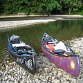
Well, curiosity got the best of us, so we tried this section on Sunday. Dale described this perfectly: "Very flat".
The river widens on this section, but never gets too deep, as if the water has finally met the bedrock and the bedrock won out. There were a few good rapids at 7.25 ft, but nothing to go back to. Although there were a lot of pools, the water moved fairly good through them at this level. We did the 9.5 miles in 3 hours in a tandem canoe. But the main reason the run seems short is because there are no pretty gravel bars to stop and spend some time. You might as well plan on eating your lunch sitting in your canoe on this stretch, parking spots are at a minimum here.
What makes this section tricky though, is the many splits in the river. There are numerous times when the river divides in two, then splits again and again. You'll find yourself without navigable water quickly, or on a blind bend clogged with trees with tricky eddies to backtrack out of.
Although there were few if any signs of civilization here (except for cow pastures lining the banks), the scenery wasn't exciting. Few if any bluffs to gaze, and no gravel bars.
Do the bridges run upriver. My guess is that the minimum level of 6 ft there will apply to both sections, so there is no reason to do the lower... except to fish.
-
T Yamashita

- Piney Creeks Chapter President
- Posts: 333
- Joined: Fri Jul 01, 2005 5:24 pm
- Location: Russellville, AR
Re: Illinois Bayou, from Scottsville bridge to Hwy 7
I'm glad you did it and reported back to us!  I've thought about doing this section, but i've been warned off from others who did it. Now my curiosity has been slackened! I hope it was a pretty afternoon for you guys,
 ty
ty


Re: Illinois Bayou, from Scottsville bridge to Hwy 7
This is a section that us dedicated canoe racers run when the water is up as a change of pace to working out on the lake. Just a easy access section with some good moving current above 7 feet.
Social Media
Who is online
Users browsing this forum: No registered users and 15 guests