Johnson's Shut Ins
Johnson's Shut Ins
Anyone ever paddle this or have any information about it? I saw some pictures and it looks like it would be fun.
-
FarPastGone
- ....

- Posts: 499
- Joined: Thu Dec 13, 2007 12:25 pm
- Name: Matt
- Location: Not Sure
- Contact:
Re: Johnson's Shut Ins
I am sure some of the KC boaters have been over there and can chime in, but you may have better luck trying:
http://missouriwhitewater.org/uieforum" onclick="window.open(this.href);return false;
- Matt
http://missouriwhitewater.org/uieforum" onclick="window.open(this.href);return false;
- Matt

Re: Johnson's Shut Ins
I've had paddlers tell me that it was scary and nobody paddled it, and I've been told that it wasn't too difficult. Missou boaters trying to throw Arkies off the trail I suspect... :)
I've been meaning to go check it out myself one of these days. I agree it does look interesting.
- Fish
I've been meaning to go check it out myself one of these days. I agree it does look interesting.
- Fish
-
perspective7

- ....
- Posts: 487
- Joined: Tue Feb 10, 2009 6:20 pm
- Name: Seth
- Location: Springfield, MO 417-761-9091
- Contact:
Re: Johnson's Shut Ins
This is from the MO version of Bill's pages...being from MO, I was curious about this run myself...
http://boatrboy.com/mocreekin/index.html
http://boatrboy.com/mocreekin/index.html
-
Cowper

- .....

- Posts: 2423
- Joined: Sun Jul 10, 2005 10:39 am
- Name: Cowper C
- Location: Conway, AR
- Contact:
Re: Johnson's Shut Ins
Wow, what a journey this little post took me on.
First, searching for paddler’s info, I ran into dire warnings like this one: NOTICE: This run is currently illegal and very dangerous due to some dam collapse trouble upstream. Don't go paddling here for now.
What the? Some more searching…
It seems that the Johnson Shut-ins is located mid-way between the upper and lower reservoirs of the Taum Sauk Pumped Storage Project. In other words, a huge farm pond was constructed on the mountain-top above this area to hold water, so that electricity could be generated during peak demand periods. But due to a combination of human errors in both the design and operation of the unit, the earthen dam was overfilled one night in December 2005, and at about 5:15 AM failed just like a New Orleans levee. A full report is here: http://www.psc.mo.gov/electric/report%2010-24-07.pdf" onclick="window.open(this.href);return false;
The full report is 85 pages, so here are just a couple of excerpts to give you an idea on the magnitude of the event:
“The reservoir drained in about 25 to 30 minutes. Approximately…1.3 billion gallons of water -- was released. The peak discharge from the breach was about 273,000 cubic feet per second (“cfs”), which occurred within 10 minutes of the initial breach. The breach flows destroyed the home of the Johnson’s Shut-Ins State Park superintendent, flooded motorists on Highway N, and significantly damaged the park, campground, and adjacent properties. The park superintendent’s children were hospitalized following the breach.”
I consider it a miracle nobody died. If this had occurred at a different time and date, it could have easily killed the dozens or even hundreds that might be playing in the Johnson Shut-ins park. Also, the dam at the lower lake did not fail, so the lower lake caught most of the water after it had travelled only 6 miles downstream, and river levels below the second dam rose only 2 feet causing no damage in downstream towns. Imagine the difference if the second dam had failed in a “domino” effect!
The dam was rebuilt and went back into operation in 2010. The new dam is concrete and has other design features to prevent another failure like the one in 2005. The park has been partially or mostly restored. Most of the dire warnings about the floating being “dangerous” were written several years ago, and some restoration of the area has occurred, so I don’t know what the current situation is; maybe our MWA brothers can tell us more about that.
To get a good view of the area, go to Google Earth and paste these coordinates into the “Fly to” box: N37.53979 W90.84
You’ll be able to link to numerous photos of the Johnson Shut-ins at low water, and a few that show the boulder fields and other damage from the blow-out. Then zoom out, and you can see the upper reservoir, the lower lake, and the scour path caused when the upper reservoir failed. The photos were apparently taken when the new concrete dam was still under construction, prior to it being refilled and put back into operation.
Trash: Get a little every time you go!

Re: Johnson's Shut Ins
Here is a video of it I found on youtube. Is this the area you're referring to? If so...there don't look to be many clean lines through much of it..unless it were at some unreal level. Either way, at low water you might get through some of it.
It looks interesting at the very least.
Joe
http://www.youtube.com/watch?v=R29UWPMilJ8
It looks interesting at the very least.
Joe
http://www.youtube.com/watch?v=R29UWPMilJ8
And all this life we've glorified
Robbin' from the blind
It's not easy, you see
Don't think i don't know sympathy
My victims in my shadow
Starin' back at me
Robbin' from the blind
It's not easy, you see
Don't think i don't know sympathy
My victims in my shadow
Starin' back at me
-
T Yamashita

- Piney Creeks Chapter President
- Posts: 333
- Joined: Fri Jul 01, 2005 5:24 pm
- Location: Russellville, AR
Re: Johnson's Shut Ins
I went through there in '07. The actual shut ins with the drops are very short and basically waterfall in a few hundred yards. It'd be like the 'tot falls constricted down to a couple boat lengths between each set and only having two or three drops. They're fun to look at, but boating? It'd also take a flood event to bring them up to any good level. It'd be worse than running the falls on the little mo- not really worth the effort and even more places to pin and get bashed. Just my two cents, ty 

Re: Johnson's Shut Ins
I've been there and it's an awesome place, but after the flood, the house sized boulders did a lot of damage to those granite spires. However, there are some kick a** creeks in the area. Fish, Cathy, and I ran one, "the pink gorge", can't remember the name of the creek, but there were like 5 high quality drops in about 1/4 to 1/2 mile with a nice trail next to the creek for lapping. There are alot of creeks in the area though that feed the st. francis.
Rokken Like Dokken
Re: Johnson's Shut Ins
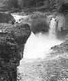
We ran the Castor R. Shut-ins that day. Here's a low water view of the pink granite. Very cool place:

- Fish
- Fish
Re: Johnson's Shut Ins
Yeah, Castor, and that's also where I got my avatar pic. Quite the magical place.
Rokken Like Dokken
-
mohawklady
- ..

- Posts: 148
- Joined: Fri Nov 30, 2007 9:06 am
- Name: pam ellwood
- Location: little rock
Re: Johnson's Shut Ins
My boys and I were frequent visitors at the shut=ins when we lived in Missouri. It is a very popular area with people from St louis and srpingfield to spend the day leisurely playing in the cascades. There are times in summer when you cant even get in the park. Also, being a ancient lava flow, the rock is very sharp and can shred you. It is not a place you can walk barefooted. I have never seen anyone go down in a boat, but have seen several inflatables shredded...Pam
-
perspective7
- ....
- Posts: 487
- Joined: Tue Feb 10, 2009 6:20 pm
- Name: Seth
- Location: Springfield, MO 417-761-9091
- Contact:
Re: Johnson's Shut Ins
Hey Cary, I have some pix from the Shut-ins area on my flickr site. I know you have allready seen some, but mine have some water...not quite boatable...but might possibly be done. A long drive for not much if you ask me...
http://www.flickr.com/photos/divinemadn ... 979406229/
http://www.flickr.com/photos/divinemadn ... 979406229/
-
Joe Purdy

- .

- Posts: 94
- Joined: Wed Jul 20, 2005 10:10 am
- Name: Joe Purdy
- Location: Fayetteville, AR
- Contact:
Re: Johnson's Shut Ins
Discovery Channel had a piece on the dam breech. It looked like a Mars landscape after the water scoured away all the dirt and vegetation.
Amazing what a little water can do.
Some of the pics of the chutes at Shut-Ins remind me of Colorado.
Amazing what a little water can do.
Some of the pics of the chutes at Shut-Ins remind me of Colorado.
I wanna leave this world the same way I came into it... naked, screaming, and covered in someone else's blood...


Re: Johnson's Shut Ins
A little water????
A billion gallons in twelve minutes blowing a 20 ft. crest down the Black!
A billion gallons in twelve minutes blowing a 20 ft. crest down the Black!
Keep Your Stick in the Water!
-Terry-
-Terry-
Social Media
Who is online
Users browsing this forum: Baidu [Spider], Google [Bot] and 5 guests