
I realize this is a missouri creek, so it is a little off topic, but there are a lot of people in springfield who are on this board, and more who travel the highway 65 corridor between Harrison/Springfield/Branson.
I will start with the disclaimer that I have not run this creek, but I have run cane creek which is very nearby. As far as I know it has not been run, but that doesn't mean anything. I have seen it running twice this spring, so in an average year it probably runs 3 to 5 days.
It is located in the Hercules glades wilderness area, so no road access, you have to hike for this one. The whitewater section starts at the first waterfall and continues to the end of the national forrest land about a mile and a half later. To reach the putin you will hike in from the parking lot by the fire tower on highway 125. There is a trail which leads down the ridge at the back of the parking lot, you take it all the way to the creek. You have two options for takeout, hike back up the trail to your car or take out at Kissee Mills on beaver creek.
I don't think it is a very technically demanding creek, but it is pretty serious for this area of the Missouri Ozarks. And by the way, I don't think we have begun to scratch the surface for creek runs in this area, I can think of several that I need to hike and assess their potential.
http://outdoors.webshots.com/album/577621696oZhExr" onclick="window.open(this.href);return false;
I hope to run it soon.
Cheers
Dan
Long creek in taney county mo
-
perspective7
- ....

- Posts: 487
- Joined: Tue Feb 10, 2009 6:20 pm
- Name: Seth
- Location: Springfield, MO 417-761-9091
- Contact:
Re: Long creek in taney county mo
Aw Yeah...I've been wanting to boat Long creek for a loooong time! I'm pretty sure it's going to be a first decent unless you know of someone that's all ready done it! I've never seen the creek with enough water to boat it...and it looks awesome! My yakin buddy hasn't seen the creek yet, but I'm sure he'd go. I would drop everything to go and run it, so give me a call sometime if the water is up and we'll meet at the tower and run the shuttle. The only take-out we could get to would be Beaver creek, right? Cane creek would have too much water to cross. Anyway..the number is (417)761-9091 Name's Seth. We are in Springfield... 
-
perspective7
- ....
- Posts: 487
- Joined: Tue Feb 10, 2009 6:20 pm
- Name: Seth
- Location: Springfield, MO 417-761-9091
- Contact:
Re: Long creek in taney county mo
There is a Terry that posts on here from Springfield that would probably go also...
Note: There are barbed wire fences down below the last trail that goes to the creek from the Beaver creek side.
What other creeks do you have in mind? How is cane creek by the way?
Note: There are barbed wire fences down below the last trail that goes to the creek from the Beaver creek side.
What other creeks do you have in mind? How is cane creek by the way?

Re: Long creek in taney county mo
Dan, Seth,
I'd be up for it if I'm not out in the Wild at work! When I'm home I can almost always happen during the week, too, if it pops!
for one7eight for8 nineoh7 six
I'd be up for it if I'm not out in the Wild at work! When I'm home I can almost always happen during the week, too, if it pops!
for one7eight for8 nineoh7 six
Keep Your Stick in the Water!
-Terry-
-Terry-
Re: Long creek in taney county mo
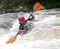
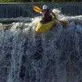
Cane creek is a great creek, it took me 3 times to finally run it, since the first two times there was two much water. It is steep and bouldery just like long creek, without the waterfalls. It is not to hazardous except for two very important places. One is an undercut that goes back 6to 8 feet, and is just plain nasty, but you can see it coming except at very high water levels. I will dig up a picture sometime soon , but not this morning since I am leaving early for work so I can cut a load of firewood on the way in.
The other place is more sneaky and in my opinion more hazardous. It comes on a sharp left bend with boulders dividing the channel. Most of the flow goes to the right channel, and it appears the way to go, but as you round the bend, all the water goes around and through a fence of rocks that won't let you through. I knew about it from hiking, so I just looked at all left turns until I got to that one.
AS for other creeks in the area, look at brushy creek, both forks of big creek, turkey creek, and more. A quick scan on google earth shows brushy creek looking like it has the goods. you can see good looking bedrock ledges from the highway bridge. I hiked the upper upper tributaries of brushy creek last weekend, and was not too impressed, but that does not matter too much since the best stuff is probably in the last mile or two above the confluance. The lower creek is private land so I probably won't get to hike it dry. When it is running I will just opt for a ninja putin and scout as I go, since I don't know where you would park.
(A ninja putin is an advanced whitewater technique requiring requiring skill, practice and, coordination between buddies. You get ready in the back of the truck somewhere else, so when you get to the bridge with no parking or river access, your buddy just slows down enough to kick you out. you run to the creek and disapear around the bend before anyone takes notice, and you have not left your vehicle to be towed.)
Later
Dan
Re: Long creek in taney county mo
Found the cane creek pictures, I know the undercut doesn't look too bad on film, but that is exactly the point as to why it can be dangerous. The boulders are just upstream of the undercut, and force you to choose a right or left line. Choose the left line and you might have a "moment", of course it all could go well, I didn't want to run that line.
- Attachments
-
-
-
Sparky
- .

- Posts: 92
- Joined: Wed Apr 15, 2009 1:51 pm
- Name: Brent Glover
- Location: Springfield, MO/Marble Falls, AR
Re: Long creek in taney county mo
We don't like to advertise our whitewater here in the Sho-Me state. I've never run Long Creek, but have hiked it numerous times. A small beautiful wilderness area heavily impacted by horses. There's no first descent here, it's been done. I've never considered it worth the effort. Mile and a half hike in and long shuttle in a very small watershed with short window of opportunity. Can be difficult creek to get off of as it flows into Beaver Creek near the takeout and Beaver Creek could be blown out making exit of the area difficult.
That being said the next watershed to the south is Cane Creek, I've run this more times than I can count over the years. A little bigger watershed and easier logistics. The lower 3 miles is what you want to run, the upper 3 aren't worth it. Gradient is a little over 30 fpm. Those of us that have run this creek over the years refer to it as "Our Hailstone". Many years back those of us at OMP fought a trailer park development on Johnson Bald above Cane Creek and managed to keep their sewage from being dumped into Cane. The creek and small waterfall in the picture of the undercut is where it would have poured in. At the time Cane Creek's water tested clean enough to drink.
Check radar for significant rainfall in SE Taney County. When you finish this run head over to Branson's finest Roark Creek. It's a bigger watershed and is usually running optimum as Cane is dropping out. Cane is a good surfing creek and Roark even better. I've run both these creeks in low flood, you just need to be very aware of strainers. The bald mountain area aroud Cane and Long creeks is extemely beautiful.
Then there's Bear Creek running north out of Harrison to near the MO border. More surfing than can be done in a day and a gauge to boot.
If you southerners want logistical info just post the request. Lots of surfing here in Southern MO.
Brent
Re: Long creek in taney county mo
Well, so much for not liking to advertise our whitewater, eh Brent?! 
Nice thing about Roark is that you can stop in the middle and take in a Shoji show and then finish the run!
They've gotten used to boaters coming in in sprayskirts to the auditorium!
Nice thing about Roark is that you can stop in the middle and take in a Shoji show and then finish the run!
They've gotten used to boaters coming in in sprayskirts to the auditorium!
Keep Your Stick in the Water!
-Terry-
-Terry-
-
elduderino
- .
- Posts: 36
- Joined: Mon Mar 24, 2008 1:32 am
- Location: Springfield, MO
- Contact:
Re: Long creek in taney county mo
Someone I know has run Long creek, and as far as I can tell, it was not the first decent. Big Jon ran this creek day before halloween, I know because I watched a video of him while we were gearing up to run Richland together. He said it was fun, a little hairy, but he didn't seem too intimidated by it.
As for taney county paddling in general, it's been my bread and butter. I have run Turkey creek, which takes out in downtown Hollister once, and paddled the Bull creek more times than I can count. As for the other creeks, I usually refer to either Jon or Barry, a guy who seems to know more about Taney county water than anyone else.
My $.02
Re: Long creek in taney county mo
Elduderino,
Where do you put in on turkey creek? I just thought you could go under the bridge on the road to the airport.
Also don't forget Bear creek in western Taney county, that guy is my bread and butter. Less than 5 miles from my house, pretty good size watershead, and mostly roadside. So much fun.
I don't have any problem advertising our whitewater, since mostly no one will run it anyway.
Dan
-
perspective7
- ....
- Posts: 487
- Joined: Tue Feb 10, 2009 6:20 pm
- Name: Seth
- Location: Springfield, MO 417-761-9091
- Contact:
Re: Long creek in taney county mo
How much rain does it take to get ol' Long creek up and going? I've looked at it when Beaver was in flood and it was hardly running. Just depends on where the heavy rain falls I guess. Swan creek used to be fun back in the day when I was 13 or so in a OC1. Bull is much better though! I'd be in for a trip down Brushy creek as well. I've been hiking and camping in all of those areas and would like to boat everything possible just to see it. "Ninja put-in" haha I like it! 
Re: Long creek in taney county mo
The pictures where all taken about a month ago, the radar estimated 4" of rainfall, but it was still falling when I was there. I got there at a good level, then it quickly rose too high. You can see from the pictures how the first drop is filling in. When I went back over beaver that day it was a little brown, but it wasn't very high. Probably hadn't risen much yet. I personally don't see the big deal with paddling a flooded beaver to kissee, it will be a brown superhighway. You could probably boat it faster than you could drive to the takeout. I have been on Bull, swan and beaver in many floods over the years, they just flatten out. There comes a point when it seems like the waves get covered up and they become boils.
I looked at the takeout issue, and I have a good solution, park at the takeout for the lower cane creek run, then when you finish long creek, walk across the field seperating the two creeks. Finish with a ferry on cane creek to your car. The walk across the field shouldn't be an issue since you probably just hiked a mile or so to get to the creek, whats a few hundred more yards? This gets you a much shorter shuttle.
The problem is when we get a flood event, it seems to follow the same pattern. First there is the anticipation, maybe you have been watching the weather and you know it is coming. Your phone blows up and maybe you are calling everyone else too. You pick a creek to run, but when everyone gets together group dynamics takes over and you might not get to run your first choice. You paddle all day and are tired at the end maybe you where lucky and got three runs in. At this pace it could be years before you get to run everything you want to in the area. This is the frustration of creeking in the ozarks.
Dan
-
Sparky
- .
- Posts: 92
- Joined: Wed Apr 15, 2009 1:51 pm
- Name: Brent Glover
- Location: Springfield, MO/Marble Falls, AR
Re: Long creek in taney county mo
I've never figured out the put in for Turkey Creek, so if someone knows the put-in road please post.
I've had a lot of experience with Cane Creek over the years, the window of opportunity is about 1/2 day. You're taking a chance anytime you go there. Years ago a local would tell us what was up and didn't mind us calling. My last high water run on Cane we had to park on the hill going into the take out. The bottom land field between Long and Cane Creeks was under due to Beaver flood. The last rapid with the undercut was flooded by Beaver. I would guess that if Long Creek is a go, then Cane should be about right when you finish up Long Creek.
Looks like developers have closed the drive in surfing at Walnut Shade on Bull Creek. Branson is slowly killing this beautiful creek. I prefer the mile of drive in surfing on Swan Creek above Forsyth, very few go there.
Look what you started Dan.
Brent
-
JasonK

- ..

- Posts: 108
- Joined: Sat Feb 23, 2008 3:38 pm
- Name: Jason Kindall
- Location: Fayetteville, Ozarkistan
Re: Long creek in taney county mo
Sparky mentioned Bear Creek in Boone County.
I remember Dad talking about a canoeing buddy of his running a stretch or two of Bear Creek back in the early 1980's. I grew up on Bear Creek and remember it fondly (before it went all to he!! due to gravel mining. I had access to pretty much any landowner's property I wanted. Sadly, that isn't the case anymore. Too much land changed hands and folks are pure paranoid these days.
I remember Dad talking about a canoeing buddy of his running a stretch or two of Bear Creek back in the early 1980's. I grew up on Bear Creek and remember it fondly (before it went all to he!! due to gravel mining. I had access to pretty much any landowner's property I wanted. Sadly, that isn't the case anymore. Too much land changed hands and folks are pure paranoid these days.
Cheers,
Jason
Jason
Re: Long creek in taney county mo
I'm with you, Brent.
There have been numerous issues on Bull. Including polution, development, gravel mining, the gamut.
Two owners ago when the property at Shady Rapid went up for sale, we tried to get the MDC or someone to buy it. It would've made a great campground/access. They wanted an outrageous price for it and it is a gorgeous property. There was even a discussion of getting a contingent of boaters together to buy it privately. That went nowhere. It was suggested to the boating club in Spfld. to try to help do something about it. Mostly by me and several others. Seemed that they couldn't be bothered to even consider it. Unfortunately, I was then a member. We were afraid the place would get chopped up and developed and access denied. Haven't been there in a while, but sounds like worst fears may be coming true.
Personally, I have always preferred the low water bridge to park & play below Shady. Never saw too many there either, as everyone always went to Shady and it was a little tricky to get into. If the water was high you had to walk in most of the way. Then the county decided that there would be no parking on the road into this spot. Though its a dead end right at the low water bridge. The road goes over the bridge and stops. The property owners around there decided that there was too much rowdiness, firearms, etc., which of course there was anything but. Several of us contacted the county regarding this, including the Legendary Angel Larry, but again to no avail.
I haven't been to either spot in about a year and a half. But I really didn't feel like taking a chance on getting ticketed by the county or brought up on trespassing charges at Shady. I have heard that several have. Guess the only recourse to get to these wonderful play spots is to just put in at Goodnight and run the entire run. Perfectly doable, but not as convenient as park & playing! At least as long as they keep that and the bridge access open at 160!
A shame.
Keep Your Stick in the Water!
-Terry-
-Terry-
Social Media
Who is online
Users browsing this forum: Ahrefs [Bot], Baidu [Spider] and 1 guest