Quick NWA Float trip

Quick NWA Float trip
New to the board and to the ACC, joined last week. Pretty new to kayaking too. Was looking for a quick day trip in northwest Arkansas. Was looking at the Elk or Kings. My biggest challenge is, my wife is 9 months pregnant and due Wed the 18th. She starts maternity leave though on Monday, was thinking was thinking about leaving her with are kids and taking the kayak out for a quick float trip. Any recommendations for like a 4 or 5 hour quick trip?
Re: Quick NWA Float trip
Options are limited for now but Enough rain might change things real quick though. Location in Nwa makes a difference as well.
In general elk, Illinois, white, or mulberry are all good bets because of all paved roads and shorter runs.
In general elk, Illinois, white, or mulberry are all good bets because of all paved roads and shorter runs.
"The challenge goes on. There are other lands and rivers, other wilderness areas, to save and to share with all. I challenge you to step forward to protect and care for the wild places you love best"
- Neil Compton
- Neil Compton
-
wiredforsound

- .....

- Posts: 824
- Joined: Mon Jul 12, 2010 11:57 am
- Name: Jeff Neisler
Re: Quick NWA Float trip
The Rock House to Trigger Gap section or for a shorter section you could do Trigger Gap to McMullen Farm on the Kings. Both would be a good options.
Link to river map here:
http://www.kingsriveroutfitters.com/riveraccess.html" onclick="window.open(this.href);return false;
Check with Ernie at Kings River Outfitters for pointers and they can also run your shuttle for you (for a fee : ).
http://www.kingsriveroutfitters.com/index.html" onclick="window.open(this.href);return false;
Jeff Neisler (aka wiredforsound, formerly known as Godzilla)
4seven9.three8one.5nine9five
4seven9.three8one.5nine9five
-
Eric Esche
- .....
- Posts: 946
- Joined: Tue Jun 13, 2006 5:01 pm
- Name: Eric Esche
- Location: Monte Ne on Beaver Lake
- Contact:
Re: Quick NWA Float trip
Another short "local" float is Big Sugar Creek into the Elk up in Pineville, MO that can be between 4 and 12 miles depending on where you put in. I took someone up there on Wednesday for her first trip in a rec boat she had borrowed and we had a good time.
I prefer the security of leaving a shuttle car at Big Elk campground on old US71, but there is a new public launch/takeout parking lot across the bridge on the north side of the river that the town and canoe liveries are pushing for folks who own their own gear and are setting their own shuttles. I'd bring a chain/cable and lock if you leave anything unattended while you run shuttle as I saw multiple groups of kids who were looking to get into something when I ran up there on Wednesday afternoon. I also picked up a full bag of garbage while we were doing our shuttle and NOT leaving our gear unattended, so the area is now clean. If you take out here, be aware that the concrete ramp is very slick with algae and there is a fast current in front of it. Better/safer to ground your boat on the bank just up stream of it on the right hand bank, but no farther than 100 feet up stream, as that is the end of the public park area and private land beyond the cable fence. There are rocks below the ramp that do not make a good eddy for taking out if you miss the ramp. We used the ramp, but I could see folks having problems there.
Directions From NWA - go up I-540 to exit "H" for pineville, go east to US 71. Big Elk campground is just before crossing bridge on right, public launch is first right and then right again after crossing bridge. Various put-ins from 2 to 12 miles on Big Sugar are found by going north through Pineville on "W" a few blocks, turning right on 8th street. Note the stop signs and 15MPH speed and school zones as they take these seriously. Never been stopped, but have seen other cars getting ticketed. After stopping at the school crosswalk, you will cross over a one lane bridge and turn left going up the valley. Road is paved and all put ins on on your right. You will see a low water bridge that can be run on the right, but can also be walked on the left. There is a public lanuch site about 4 miles up stream. Road is curvy and allows glimpses of the river in places. The narrow 2 lane road is marked as high as 45MPH in places, but 35 is safer if you are looking at the water, not sure of where you are going, and are allowing for no shoulders with drop off in places and two way traffic with the sun in someone's eyes.
I prefer an unmarked private $5/car/day "coffeecan honor system" launch or camp site at about the 6 mile point called Owls Nest, although any sign on the road is long gone. To find it, look for a blue building on your left and then take the next dirt road to the right at the edge of a fenced clearing. Never had a problem with vehicle safety here and lots of places to park in shade. It's a 3 hour float from here unless you are fishing. There are other livery launch sites up stream with the last being at Cyclone. Do not know if they are open yet as the season for them has not really started.
Note the number of no parking and tow away zone signs at Cyclone, and use a livery for parking or have someone drop you off. Bring lots of cash if you use a livery for parking or a shuttle as most do not take plastic and they can be expensive with some charging as much as $20 just to park one car for one person with rates varying wildly between places. Have no idea what a shuttle would run as I have always run my own here, but know one place I did NOT use asked $60/person. Had been there previous years while chaparoneing/sheepdogging a church group and it was $20, but with new owners, the rates changed drastically. That place was south of the bridge on the Elk river on the right bank. Big Elk campground on the left bank has always been a quality operation in my experience with a really nice staff that welcome private boaters if you want to use their facilities and pay for them and whose rates were not unreasonable.
Good minimum flow for Cyclone down is 120CFS, 90-100cfs for lower sections.
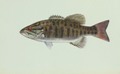
Lots of turtles, grey herron, ducks, kingfishers, vultures, and sometimes eagles. Fairly good number of fish, mostly varieties of bass who have to be over 15" to keep, and then only after a certain date, I think in May. Never fished it, but saw a sign that I obviously did not read well enough in the public launch lot. Also see beaver, muskrat, otters, mink and skunks on occasion.
Big Sugar is class one scenic floating through wooded farmland, maybe class two at higher levels due to snags and root balls. Many of those. Stay to inside of turns and you should avoid most of them. Gravel bottom shifts a lot and often, enough that I assume I may not know where it goes or what hazards are there from week to week, as I have seen it change that fast. Trees and low limbs over the river are a common occurance, but 5 places that were portages a month ago are not there now, probably due to the liveries getting things ready for their rental season.
If you are going during the week, give me a shout and I might can go with you if my honeydo list is not too full or it is deferrable that day. I allow about an hour from Rogers drive time each way. Farther in advance I know, easier it is to shift things around and plan.
Here's the gauge if you want to check the flow:
http://waterdata.usgs.gov/mo/nwis/uv?cb ... o=07188653" onclick="window.open(this.href);return false;
Eric Esche
I prefer the security of leaving a shuttle car at Big Elk campground on old US71, but there is a new public launch/takeout parking lot across the bridge on the north side of the river that the town and canoe liveries are pushing for folks who own their own gear and are setting their own shuttles. I'd bring a chain/cable and lock if you leave anything unattended while you run shuttle as I saw multiple groups of kids who were looking to get into something when I ran up there on Wednesday afternoon. I also picked up a full bag of garbage while we were doing our shuttle and NOT leaving our gear unattended, so the area is now clean. If you take out here, be aware that the concrete ramp is very slick with algae and there is a fast current in front of it. Better/safer to ground your boat on the bank just up stream of it on the right hand bank, but no farther than 100 feet up stream, as that is the end of the public park area and private land beyond the cable fence. There are rocks below the ramp that do not make a good eddy for taking out if you miss the ramp. We used the ramp, but I could see folks having problems there.
Directions From NWA - go up I-540 to exit "H" for pineville, go east to US 71. Big Elk campground is just before crossing bridge on right, public launch is first right and then right again after crossing bridge. Various put-ins from 2 to 12 miles on Big Sugar are found by going north through Pineville on "W" a few blocks, turning right on 8th street. Note the stop signs and 15MPH speed and school zones as they take these seriously. Never been stopped, but have seen other cars getting ticketed. After stopping at the school crosswalk, you will cross over a one lane bridge and turn left going up the valley. Road is paved and all put ins on on your right. You will see a low water bridge that can be run on the right, but can also be walked on the left. There is a public lanuch site about 4 miles up stream. Road is curvy and allows glimpses of the river in places. The narrow 2 lane road is marked as high as 45MPH in places, but 35 is safer if you are looking at the water, not sure of where you are going, and are allowing for no shoulders with drop off in places and two way traffic with the sun in someone's eyes.
I prefer an unmarked private $5/car/day "coffeecan honor system" launch or camp site at about the 6 mile point called Owls Nest, although any sign on the road is long gone. To find it, look for a blue building on your left and then take the next dirt road to the right at the edge of a fenced clearing. Never had a problem with vehicle safety here and lots of places to park in shade. It's a 3 hour float from here unless you are fishing. There are other livery launch sites up stream with the last being at Cyclone. Do not know if they are open yet as the season for them has not really started.
Note the number of no parking and tow away zone signs at Cyclone, and use a livery for parking or have someone drop you off. Bring lots of cash if you use a livery for parking or a shuttle as most do not take plastic and they can be expensive with some charging as much as $20 just to park one car for one person with rates varying wildly between places. Have no idea what a shuttle would run as I have always run my own here, but know one place I did NOT use asked $60/person. Had been there previous years while chaparoneing/sheepdogging a church group and it was $20, but with new owners, the rates changed drastically. That place was south of the bridge on the Elk river on the right bank. Big Elk campground on the left bank has always been a quality operation in my experience with a really nice staff that welcome private boaters if you want to use their facilities and pay for them and whose rates were not unreasonable.
Good minimum flow for Cyclone down is 120CFS, 90-100cfs for lower sections.
Lots of turtles, grey herron, ducks, kingfishers, vultures, and sometimes eagles. Fairly good number of fish, mostly varieties of bass who have to be over 15" to keep, and then only after a certain date, I think in May. Never fished it, but saw a sign that I obviously did not read well enough in the public launch lot. Also see beaver, muskrat, otters, mink and skunks on occasion.
Big Sugar is class one scenic floating through wooded farmland, maybe class two at higher levels due to snags and root balls. Many of those. Stay to inside of turns and you should avoid most of them. Gravel bottom shifts a lot and often, enough that I assume I may not know where it goes or what hazards are there from week to week, as I have seen it change that fast. Trees and low limbs over the river are a common occurance, but 5 places that were portages a month ago are not there now, probably due to the liveries getting things ready for their rental season.
If you are going during the week, give me a shout and I might can go with you if my honeydo list is not too full or it is deferrable that day. I allow about an hour from Rogers drive time each way. Farther in advance I know, easier it is to shift things around and plan.
Here's the gauge if you want to check the flow:
http://waterdata.usgs.gov/mo/nwis/uv?cb ... o=07188653" onclick="window.open(this.href);return false;
Eric Esche
Last edited by Eric Esche on Sat Apr 14, 2012 11:15 pm, edited 1 time in total.
Re: Quick NWA Float trip
Wow thanks guys. And Eric thanks for the abundance of info. You wouldn't happen to know anything about the little sugar creek? I live in Pea Ridge and was thinking about putting in by the HWY 72 bridge and taking out at Bella Vista lake since it runs right to it. The google earth pictures look promising. Maybe a few places to portage but with this weather system coming in may bring the creek up to a nice level. A buddy and I are planning either a monday or tuesday excursion on it, weather permitting, and if my wife has still not gone into labor. If anyone is interested your more then welcome, I should have more specifics late tonight after work.
I figure this will put me close enough to home and civilization if the wife calls, I can get to the hospital quick.
I figure this will put me close enough to home and civilization if the wife calls, I can get to the hospital quick.
-
Al Donaldson
- ..

- Posts: 147
- Joined: Sun Jan 28, 2007 11:04 am
- Location: Cedar Falls, IA
Other gage
MP:
I think Eric may have given the gage for the Little Sugar. Big Sugar gage is here:
http://waterdata.usgs.gov/mo/nwis/uv?cb ... o=07188653" onclick="window.open(this.href);return false;
Regards,
al
I think Eric may have given the gage for the Little Sugar. Big Sugar gage is here:
http://waterdata.usgs.gov/mo/nwis/uv?cb ... o=07188653" onclick="window.open(this.href);return false;
Regards,
al
-
Eric Esche
- .....
- Posts: 946
- Joined: Tue Jun 13, 2006 5:01 pm
- Name: Eric Esche
- Location: Monte Ne on Beaver Lake
- Contact:
Re: Quick NWA Float trip
Al is correct - I had the wrong gauge listed, but I have now edited the post to show the correct gauge for BIG Sugar creek.
Thanks For the catch Al. Looking forward to paddleing with you next Sunday and Monday. Here's hoping we get some rain before then. Supposed to get some tomorrow.
Eric Esche
Thanks For the catch Al. Looking forward to paddleing with you next Sunday and Monday. Here's hoping we get some rain before then. Supposed to get some tomorrow.
Eric Esche
-
Eric Esche
- .....
- Posts: 946
- Joined: Tue Jun 13, 2006 5:01 pm
- Name: Eric Esche
- Location: Monte Ne on Beaver Lake
- Contact:
Re: Quick NWA Float trip
See the post for a trip 4/22 Sunday. Now probably Little Sugar, but I do not know which section - Going where Al got the directions to.
Eric Esche
Eric Esche
Social Media
Who is online
Users browsing this forum: No registered users and 7 guests