I am planning on camping at Dagmar and floating Bayou DeView Sat/Sun. I noticed the Brinkley area is under flood warning until Friday. What does a flood do to this area, aside from raising the water level on the river/swamp. Does the camping area/access roads in Dagmar go under water? Are there any particular dangers to watch for.
This will be my 4th year there so I am pretty familiar with the area. Just haven't gone when it was in flood stage.
Thanks,
kru
Bayou DeView/Dagmar Question, Trip Report
Bayou DeView/Dagmar Question, Trip Report
Last edited by kru1 on Tue Mar 17, 2015 10:14 am, edited 1 time in total.
I say, and I intend it emphatically, let the river be.
Thomas Hart Benton, on the Buffalo River
Thomas Hart Benton, on the Buffalo River

Re: Bayou DeView/Dagmar Question
I believe there are rules in place that say if the Clarenden (?) gage is over a certain level then the roads in Dagmar will have their gates shut. Cowper and Debo will know more... I replied mostly so I can see that answer.
Bryan Signorelli
Re: Bayou DeView/Dagmar Question
Dagmar is in Floodprone Region D...
http://www.agfc.com/hunting/Pages/Hunti ... gions.aspx" onclick="window.open(this.href);return false;
http://www.agfc.com/hunting/Pages/Hunti ... gions.aspx" onclick="window.open(this.href);return false;
Bryan Signorelli
Re: Bayou DeView/Dagmar Question
The Brinkely gage should be at 14 feet or above. It is currently close to 16 feet and rising. It will hold near that level for about a week since the upstream gage at Morton is flooding and over 18 feet. The Clarendon gage is over 24 feet and this is still in the normal range but the Augusta gage upstream on the White is 28 ft and at flood stage so more water is coming down river. The Cache is also at flood.
Ok, so what does this all mean? The Dagmar road will certainly go under water if the Clarendon gage goes to 27 feet. The Cache River being at flood will also have some effect on levels in Deview. Both the White and the Cache back up into Deview at flood. Conditions are ripe for the road to go under.
As you can see the hydrological relationships in the Delta are very complex. I am still in the process of calibrating all the combinations and what they mean.
I just told you all of this because I find the complexity of the flow patterns fascinating. I hope you do too.
As for safety of paddling, the water is still going to move fairly slowly and come to a stop as it hits the backup water of the Cache and the White. This usually happens at the spread out area above the access spur trail upstream of Hickson Lake. it is easy paddling but a little harder to find a good place to empty your boat if you do turn over. This stage is great for striking out off trail and exploring because you can go anywhere. Just be sure to have your GPS.
If the Dagmar road is flooded, I recommend putting in at Brinkley and taking out at the railroad bridge or the AGFC access at Apple Lake. I think you can still camp there also.
Mikki White and I are paddling there tomorrow. Can't wait! I will be watching the Gage's and taking notes on what I see tomorrow.
I will have a further report then.
Cache White river etc. gauges: Flood stage 27 feet.
http://www.weatherforyou.com/reports/in ... code=72029" onclick="window.open(this.href);return false;
Deview at Brinkley gauge Hwy 17: good paddling at 14 feet and above.
http://waterdata.usgs.gov/ar/nwis/uv?site_no=07077730" onclick="window.open(this.href);return false;
Deview at Morton: usually rises before Brinkley. Rule of thumb: If Morton rises to 17 feet or more and holds for three days above 15 feet, the water trail at Hwy 17 will have water to paddle six days
after the Morton gauge first went up.
http://www2.mvr.usace.army.mil/WaterCon ... &fid=&dt=S" onclick="window.open(this.href);return false;
Last edited by DeBo on Tue Mar 10, 2015 4:44 pm, edited 1 time in total.
“What we do for ourselves dies with us. What we do for others and the world remains and is immortal.” Albert Pine
-
Cowper

- .....

- Posts: 2423
- Joined: Sun Jul 10, 2005 10:39 am
- Name: Cowper C
- Location: Conway, AR
- Contact:
Re: Bayou DeView/Dagmar Question
The north access road AT WATTENSAW will still be open, with some camping above water IN WATTENSAW, which is not too far down the road from BDV and Dagmar. Road to Hickson may go under, need Debbies report. Look at map for highway crossings above Hwy 17, east of Cotton Plant, you can put in there and go to 17, its great st this level. I'm late for work and doing this from memory, Debbie please add highway numbers, there are some floats even higher up that are also great. 17 feet and above is my favorite level!
(Sorry I was tired when I answered that, hopefully the edit will eliminate some confusion.) All of the "camping permitted" areas in Dagmar are past the gate that gets closed during high water. Debbie says she's shared some additional info privately, so I won't ramble on.
(Sorry I was tired when I answered that, hopefully the edit will eliminate some confusion.) All of the "camping permitted" areas in Dagmar are past the gate that gets closed during high water. Debbie says she's shared some additional info privately, so I won't ramble on.
Last edited by Cowper on Thu Mar 12, 2015 11:37 pm, edited 1 time in total.
Trash: Get a little every time you go!
Re: Bayou DeView/Dagmar Question
Ok, What Cowper said. There are several good floats upstream of Hwy17. We know the most about two of these sections. Neither one of these sections are signed.
First:
Put in at the Hwy38 bridge east of Cotton Plant and take out at Hwy17. This paddle is a little over 9 miles and the middle part of it is a real bushwhack. GPS is highly recommended. It's a great trip if you get an early start and can be an adventure if you don't. This is a great water level for it.
Second:
Put in at Hwy306 bridge and take out Hwy38. This paddle is almost 5 miles and the river is easier to follow. If you have several cars in your group try to leave as many as you can at the takeout because parking is limited at the put in.
“What we do for ourselves dies with us. What we do for others and the world remains and is immortal.” Albert Pine
Re: Bayou DeView/Dagmar Question
Thanks for all of the information.
We have paddled Hwy 38 to 17, and Hickson Lake to Apple Lake. We have also spent many hours exploring what I call the Rookery Backwater between Hickson and Bayou De View. I was going to try to get Hwy 17 to either Hickson or Apple Lake on this trip.
I spoke with Garret at Arkansas Game & Fish. There is no set rule for locking the gates at Dagmar. There are 3 different systems feeding Dagmar (Bayou De View, Cache, and White, and also locally the Robe), and they monitor them all. They assess the situation on site. He mentioned that they do have two gates, one at Gator Pond past the interstate and then one at the headquarters. He said that they usually lock Gator Pond first, but that still leaves 4/5 campsites open and access to Teal Pond and the Bayou De View at the old Railroad Crossing. He said that they try to make that call on Friday since they don't like to have to work on the weekends. He will call me and let me know their decision tomorrow afternoon. He also mentioned that if they have to lock both gates we can always camp at Wattensaw Bayou. He also said that Game & Fish lands never close, just the roads if they are unsafe for driving.
kru
I say, and I intend it emphatically, let the river be.
Thomas Hart Benton, on the Buffalo River
Thomas Hart Benton, on the Buffalo River
Re: Bayou DeView/Dagmar Question
Mikki White and I were out there yesterday. The water is almost even with the road as you get close to Hickson. The paddling is easy and wildlife was abundant. Great day!
Have fun out there.
Have fun out there.
“What we do for ourselves dies with us. What we do for others and the world remains and is immortal.” Albert Pine
Re: Bayou DeView/Dagmar Question
As promised Garrett, from the Game and Fish, called me at 9am on Friday morning to inform me that they were about to lock the Gator Pond gate. He said that water was covering a good bit of the road past the interstate in Dagmar. He also said that he had to close the gate to Teal Pond because it was covered as well and said that the road to the old railroad crossing access point was nearly under water. He also said that their job on Friday was to chase a few campers out and to move all of their gear from the park headquarters into the city of Brinkley. I.e. they were preparing for the entire area to flood. The Claredon gauge on the White was at 27' and the Patterson gauge on the Cache was at 12'. Both of which were considered in flood.
The six of us decided to camp at Wattensaw Bayou instead where there was plenty of high ground. We camped at the the North Access canoe trail put-in. Although the water was high on the Wattensaw, there was really no chance of our campsite to flood.
It took about an hour to get to the Hwy 17 put-in on Bayou De View on Saturday. We set shuttle at Apple Lake since Hickson Lake was closed and I guessed that the old Railroad crossing access was closed as well. We were floating by 1:00 in a light drizzle. The water was high and moving at a good speed through Hwy 17 Lake. However, it quickly backed up and there was no current for the rest of the trip. That meant that we had an 11 mile long pool. It was gorgeous and wildlife was abundant. We took it slow at first and by 4 in the afternoon realized that we had only covered 3 of the 11 miles. We kicked it in gear for the rest of the trip to make it to the take out by dark. Never really had time to explore, but we had a blast bouncing from blaze to blaze and trying to find short cuts. The blazes were about a foot out of the water. We made it to Apple Lake with plenty of daylight to spear, but we were all tired.
On Sunday we made the decision to float the Wattensaw Bayou canoe trail. I didn't think that I would enjoy it that much, but I was wrong. Turned out to be the highlight of the trip for me. The water was so high that all of the bottom hardwood forests were under water. I have never paddled through a hardwood forest and it was cool. Within an hour I was lathering myself in sunblock and enjoying the sunshine for the first time this year. We leisurely paddled the 8 mile float, cutting off as many noses of the ridges as we could so we could paddle in the forest. We found the float camp and made a visit. Looks like a great place to camp. We got off the river by 5 and made our way back to NWA.
It was hard to pass up all of the whitewater we had across Arkansas, but this is an annual trip for us and had been planned well in advance. The reward was getting to see those streams in flood stage. It made everything worth it. Thanks to all that gave me information. Plan B worked out flawless.
kru
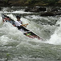
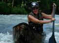
- Attachments
-
- Bayou De View in high water and light mist
-
- Pulling over for lunch at the midway access point on Wattensaw
-
- Approaching the old railroad crossing on the Wattensaw Bayou
-
- Paddling through the hardwood forest on the Wattensaw Bayou
I say, and I intend it emphatically, let the river be.
Thomas Hart Benton, on the Buffalo River
Thomas Hart Benton, on the Buffalo River
Re: Bayou DeView/Dagmar Question, Trip Report
Thanks for the trip report. I did the 17 to Apple Lake trip with some folks from Memphis on Sunday. Great trip. Our signs appeared to be in good shape. We pulled out for lunch and a pit stop on Whiskey Island. Got off around 4:00pm.
Wattensaw is always a good trip and different at every level. I like it both at high water paddling among the hard woods or at very low water through the massive bases of the cypress trees.
Wattensaw is always a good trip and different at every level. I like it both at high water paddling among the hard woods or at very low water through the massive bases of the cypress trees.
“What we do for ourselves dies with us. What we do for others and the world remains and is immortal.” Albert Pine
-
leonemeister
- .

- Posts: 3
- Joined: Sat Mar 23, 2024 1:05 pm
- Name: Michael Leone
Re: Bayou DeView/Dagmar Question, Trip Report
Hello! On April 1 I am flying into Brinkley to check out Bayou de View. The only problem is: I don't have a canoe or kayak! Does anybody or anyplace within the area provide rentals? I haven't seen much of anything online. Alternately, are there any local tour guides anybody knows about?
Thank you for your assistance!
Best,
Michael
Thank you for your assistance!
Best,
Michael
Social Media
Who is online
Users browsing this forum: No registered users and 29 guests